Tag Archives: Hurricane Irene

Hurricane Sandy, the Frankenstorm

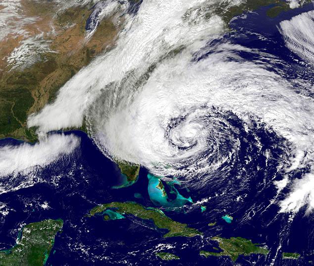
Hurricane Sandy, NOAA handout satellite image taken on October 27, 2012.

Hurricane Sandy, NOAA handout satellite image taken on October 27, 2012. Note the size and position of the storm.

Hurricane Sandy, aka “The Frankenstorm,” a Hurricane with Snow, the 19th named storm of the 2012 season, is projected to hit Delaware, then New Jersey, New York, Connecticut, and Massachusetts, Vermont, New Hampshire, and Maine. Snow is expected in West Virginia. Winds and rain are expected as far west as Ohio. Additional satellite images are available at NOAA. Note that the Frankenstein monster was created by man.
While some are calling this the storm of the century, I see it, like Hurricane Irene of 2011, discussed here, and Katrina and Rita a few years ago, as a harbinger of things to come.
Several natural phenomena are combining with several man-made factors to interact in ways that will make this a very significant storm, and one that we expect to see repeated every few years.  ABC News, National Hurricane Center, NOAA, other news and information media are providing up-to-date coverage.  Popular Logistics provides analysis.
Natural Phenomena:
  • Hurricane Sandy is 900 miles wide – bigger than Irene.
  • It will interact with a cold front coming from Canada that will form a Nor’ Easter.
  • It will also interact with the Jet Stream, that will pull it northward, then refocus it back south-westerly arc toward New York City, Long Island, and New Jersey.
  • The full moon – which triggers higher tides – will trigger a storm surge.

Man made factors that will exacerbate the storm’s damage:

  • Atmospheric CO2 and water vapor – the concentration of carbon dioxide and water vapor is higher today due to burning fossil fuels.  This means the atmosphere can hold more heat, and is holding more water, the oceans are warmer; thus storms will be bigger and more severe.
  • Coastal development – sand dunes gone from Long Island make us more vulnerable to storm surges and flooding
  • Crumbling infrastructure gives us a diminished ability to weather the storm.
  • Lack of emergency preparedness gives us a diminished ability to weather the storm.
  • Satellites, in need of repair, give us a diminished ability to monitor the storm.
  • Nuclear Power plants in New York, New Jersey, and Connecticut will need to be monitored. Some will be shut down, as they were last year during Hurricane Irene, leading to power outages. See “Nuclear Power, Natural Disasters, and Security.”This gives us diminished ability to weather the storm, and forces us to deploy resources to safeguard infrastructure.

In August of 2011 the Millstone 2 & 3 plants in Connecticut and the Brunswick 1 & 2 plants in North Carolina were operated at reduced capacity during and after Hurricane Irene, while the Oyster Creek plant in New Jersey, and the North Anna 1 & 2 plants in Virginia, were offline.  The North Anna plants were shut down before the hurricane due to the earthquake. I expect Hurricane Sandy will effect most of those plants, and also the Calvert Creek plant in Maryland, Hope Creek, and Salem in Jersey, Indian Point in New York, and Vermont Yankee, in Vermont.

Solar power, wind, and wave power won’t work during a hurricane, but don’t need emergency crew on hand to make sure cooling systems are operational. And geothermal will function.

As an analyst with Popular Logistics, I am available for research and analysis on a per project or a per diem basis. I can be reached at ‘L Furman 97” @ G Mail . com and US 732 .  580 . 0024.
Nuclear Power, Natural Disasters, and Security

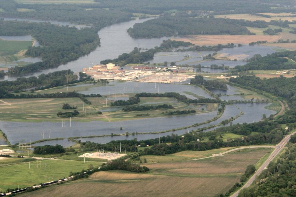
Fort Calhoun Nuclear Plant, near Omaha, Nebraska, in the middle of the Missouri River

  Follow LJF97 on Twitter Tweet  Nuclear power diminishes  National Security and the stability of the electric grid.

Consider the Brunswick, Fort Calhoun, Millstone, North Anna, and Oyster Creek nuclear power plants, and the Fukushima melt-downs. And consider the “Mobley Factor.”

The Brunswick nuclear plants in North Carolina, and the Millstone nuclear power plants in Connecticut were brought to “reduced power” in preparation for Hurricane Irene.  The Oyster Creek plant in New Jersey was shut down.  The North Anna nuclear plant, about 90 miles from Richmond, Virginia, was shut down Because of the earthquake that hit the east coast of the United States on Tuesday, August, 23, 2011( Popular Logistics coverage here).  The Fort Calhoun, Nebraska, nuclear plant, pictured above, near Omaha, Nebraska, shut down in May, 2011, for refueling, remains shut down (losing $1.0 million per day) due to the flooding of the Missouri River that began June 6, 2011. (Popular Logistics coverage here and here, photos are here).

In an emergency we know that nuclear plants will be shut down, and therefore not generating power. However, they will require  emergency power and emergency response resources.

“The Mobley Factor” refers to Sharif Mobley, an American currently in prison in Yemen, suspected of ties to Al Queda. Before going to Yemen, Mr. Mobley worked as a laborer in six nuclear power plants in New Jersey, Pennsylvania, and Maryland, including the Salem and Hope Creek plants in New Jersey, the Peach Bottom, Limerick and Three Mile Island plants in Pennsylvania, and the Calvert Cliffs plant in Maryland. Mr. Mobley had unrestricted access to those plants. Equipped with a cell phone he could have taken pictures, lots of pictures, also known as “Actionable Intelligence.”

Bloomberg News reported (here) “Federal regulations require nuclear reactors to be in a ‘safe shutdown condition,’ cooled to less than 300 degrees Fahrenheit, two hours before hurricane-force winds strike.” Paradoxical, but nuclear power plants – a source of power – depend on fossil fuel.

The Bloomberg News article continues, “Plant operators typically begin shutting down reactors 12 hours before winds exceeding 74 miles per hour are predicted to arrive, said Roger Hannah, a spokesman with the U.S. Nuclear Regulatory Commission’s Region II office in Atlanta.”

Reuters (here) reported that the operators are working to bring online the various nuclear power plants shut down due to the hurricane and the earthquake.

STATE         OWNER      PLANT          STATUS   RESTART      CAPACITY MW
--------------------------------------------------------------------------
Connecticut   Dominion   Millstone 2    REDUCED  UNKNOWN         884
Connecticut   Dominion   Millstone 3    REDUCED  UNKNOWN       1,227
New Jersey    Exelon     Oyster Creek   OFFLINE  UNKNOWN         619
N. Carolina   Progress   Brunswick 1    REDUCED  24-36 Hours     938
N. Carolina   Progress   Brunswick 1    REDUCED  24-36 Hours     937
Virginia      Dominion   North Anna 1   OFFLINE  UNKNOWN         980.5
Virginia      Dominion   North Anna 2   OFFLINE  UNKNOWN         972.9
Nebraska                 Fort Calhoun   OFFLINE  UNKNOWN         484
--------------------------------------------------------------------------

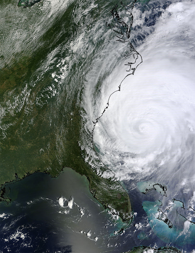
Follow LJF97 on Twitter Tweet  “Irene is especially worrisome … because of its uncommonly massive size. According to Ron Steve, a meteorologist at the National Weather Service’s Wilmington Office, Irene covers an area of approximately 170,000 square miles, or about the size of California or Iraq.”  Star News Online.

The storm had a 400 miles north to south and covered 170,000 square miles – about the size of California.