The “Seven Seas” are really one big interconnected ocean. While many people may have been unconscious of this fact, we, meaning humanity, have known this since 1522, when, led by Juan Sebastian Elcano, the 18 remaining members of Ferdinand Magellan’s 237 man crew completed the circumnavigation of the earth, begun in 1519. This lesson has been reinforced by images from aircraft, spacecraft, and satellites. We have also known about the “Southern Oscillation (SO) since the 1920’s. As described by Sir Gilbert Walker, “When pressure is high in the Pacific Ocean, it tends to be low in the Indian Ocean from Africa to Australia.”
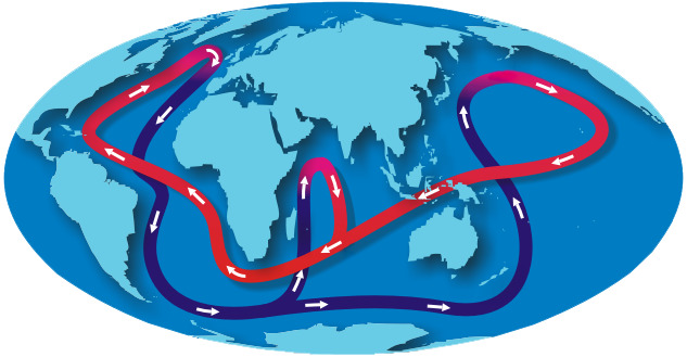
 We also now are beginning to understand that the there is a tremendous current, the Great Ocean Conveyor Belt, which traverses the Pacific, the Indian, and the Atlantic, which interacts with winds, which maintains the Gulf Stream, and transports energy towards the poles. For more on this, including the image, above, see the National Weather Service and NOAA web pages . The red band is warmer water near the surface; the dark blue band is denser, colder, water that runs deeper.
A global circulation which extends to the depths of the sea called the Great Ocean Conveyor. Also called the thermohaline circulation, it is driven by differences in the density of the sea water which is controlled by temperature (thermal) and salinity (haline).
The Gulf Stream is part of the Great Ocean Conveyor, which is why the waters off the Jersey Shore are always warm in September. How does this effect climate change and climate stabilization? And how do El Nino and La Nina effect the Great Ocean Conveyor? I don’t know. I think the Great Ocean Conveyor serves to dampen the magnitude of fluctuations in weather and changes in the climate. However, I also think there is evidence to suggest that El Nino and the Southern Oscillation (ENSO) have been more pronounced in recent years, and these may have be related to the earthquakes that triggered the tsunamis that hit Indonesia in 2004 and 2009.
Stay tuned.