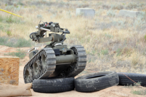
Extreme Hazard robot essaying an obstacle course at the Robotic Vehicle Range, Kirtland AFB, Albuquerque, NM. Sandia National Labs.
A sultry day was in the offing near Purnell OK, the seat of McCurtain County in the state’s southeast quadrant, just a dozen miles northwest from the triple point where Arkansas, Texas and Oklahoma meet. One hundred forty miles northeast, the National Weather Service Doppler radar station KSRX at Ft. Smith Arkansas, was monitoring a cold front approaching from the west, driven by a mass of cool dry air sweeping down from the northern plains. Typical for the late spring in the American prairie, this eastbound mass was colliding with a warm, wet air mass streaming north from the Gulf of Mexico, now roiling under a cool dry tongue at 700 mb. Buoyant but trapped under heavier cool air, supercells were forming in the humid 850 mb surface layer twenty miles west of Purnell.
